


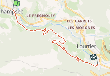
Champsec, Sentier Raquettes n° 5, Champsec - Le Rosay

verbier
User


2h00
Difficulty : Unknown

FREE GPS app for hiking
 SityTrail
IGN / Geographical institutes
SityTrail Plus
The world is yours!
About
Trail Snowshoes of 3.8 km to be discovered at Valais/Wallis, Entremont, Val de Bagnes. This trail is proposed by verbier.
Description
Départ du village de Champsec (906 m) direction camping de la Sasse (929 m). Suivre le chemin pédestre jusqu’au lieu-dit La Tinte (1''150 m) puis deux variantes possibles :
1. traverser le pont de la Dranse direction Le Rosay (1''071 m) jusqu’à Lourtier (1''087 m)
2. suivre les balises jusqu’à la Gare des Glariers (1''094 m).


Positioning
Comments